🥾 Walk 593 - Crowthorne Woods, Caesar’s Camp & the Devil’s Highway
On Sunday 23rd July we had a morning walk, which was five miles and started at 9:30 - a bit earlier than our usual walks. It was quite a nice morning, being sunny and warm but not too hot. Fourteen of us, plus two dogs, met up at Great Hollands recreation ground car park. Another caught us up and joined us soon after we started.
We set off along a woodland path that brought us out by the road junction of Nine Mile Ride and Foresters Way, near the Golden Retriever pub. Crossing this complicated junction, we continued to follow Nine Mile Ride eastward, not on the pavement but parallel with it along a wooded footpath.
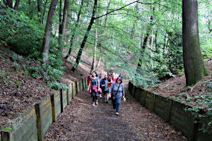
After a short while, we crossed the road and headed south into Caesar's Camp - an Iron Age hill fort around 2400 years old and probably wasn't used as a Roman camp, despite its proximity to the Roman Road known as the Devil's Highway. This road connected Calleva Atrebatum (Silchester) to Londinium (London).
Leaving Caesar's Camp, we headed east, south-east and then south to some buried reservoir tanks. Just behind them was Upper Star Post (also known as Roman Star Post) - a junction of six paths, including the aforementioned diabolical Roman road.

So we joined the Devil's Highway and followed it westward for about a mile, sharing it with cyclists and dog walkers alike. We stopped at the point where the Roman Road passed under the somewhat more modern A3094 Foresters Way. Turning right, we walked through mixed woodland to Wickham Bushes.
Wickham Bushes is known to be the site of a small Roman settlement, as plenty of pottery and other Roman artefacts have been found here to prove it (unlike Caesar's Camp where there is little evidence of Roman occupation, despite the name!)

On the way there, we passed the remains of a reboubt that had been part of a defence line built in 1792 in preparation for the Napoleonic Wars. It was now very overgrown and could easily have been missed if our leader hadn't stopped us and pointed it out.
Leaving Wickham Bushes, we headed north through Scots pines to Hut Hill. An open clearing at the top allowed us to see quite a few identifiable buildings in Bracknell, plus a few in Reading and Wokingham.

From Hut Hill, we descended northward, back on to Nine Mile Ride. We followed this to the junction with Foresters Way and, while standing on a large traffic island, split up. Those wanting to stop off at The Golden Retriever for refreshments went one way, while those wanting to go straight home retraced our outgoing route back to the car park. See our route on Google Maps.
Being a warm day, if a little overcast, we sat outside The Golden Retriever and enjoyed our drinks. Having started at 9:30 and because the walk was just 5 miles, without a lunch-stop, we'd finished the walk at 11:30, just in time for the pub to open!

Thank you to Sue for leading this walk and Jonathan for back-marking.
📸 Back to Volume 45
Return to volume index