We had twelve people on our walk on Sunday 30th April. This was a walk I'd devised a few weeks earlier and Emma came with me for the recce. She'd used my map to successfully navigate during the recce and had volunteered to be my co-leader on the day. In fact, I rather sneakily handed her the map just as we started and she led the group for the whole walk - and did a great job of it.
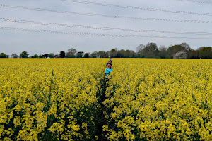
We started from the English Heritage car park by the remains of the Roman town of Calleva Atrebatum and took the path that crossed it from the West Gate to the East Gate, emerging by the church of St. Mary the Virgin. After a quick look around the Amphitheatre, we continued eastward through a couple of fields, one containing oilseed rape, which had grown considerably since our recce. It was now shoulder high!
Leaving the field, we followed the course of The Devil's Highway along a quiet and not at all diabolical lane. It wasn't long before we left it and took a footpath northward across a field and over the railway on a pedestrian bridge. Now heading north-east, we followed the course of Foundry Brook to another church of St Mary the Virgin - this one in Stratfield Mortimer.
Crossing the main road, we walked along Mortimer Lane and then along a footpath through Wheat's Farm to Nightingale Lane. A narrow footpath opened into fields on Mann's Farm. Zig-zagging northward, we crossed Lockram Brook into Wokefield Farm. Then a short walk along Lockram Lane took us into Wokefield Common. Here we stopped to eat our packed lunches, sitting by Pullen's Pond.
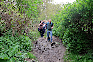
After lunch we traversed the woodland of Wokefield Common and then Starvale Woods, crossing Lockram Brook again. A particularly muddy path had to be endured as we passed Bridge's Farm on our way to Mortimer village. Some hand-holding was helpful for getting people across the deepest of the muddy puddles - something that would have been frowned upon during the recent pandemic. (Hand-holding, that is. Not crossing muddy puddles, of course.)
In the village, we stopped at The Horse and Groom for a drink and sat outside watching the goats and ducks that live at the back of the pub garden. Refreshed, we set off along the main road, then West End Road and down Summerlug (an old back-lane) taking us out of the village and into Mortimer West End.

Walking along Turk's Lane, we came across a county boundary marker. Mortimer appears to be in Berkshire and Mortimer West End in Hampshire. We stopped for a group photo, dividing ourselves into Berkshire residents and Hampshire residents, standing on the appropriate sides of the boundary marker. The Berkshire residents clearly outnumber the Hampshire ones.
Continuing along Turk's Lane, we branched into Simms Farm Lane and walked up the drive of Rose Cottage! We weren't trespassing as there is a public footpath there, which led us along the edge of a field and into a narrow and winding woodland path through Simms's Copse. Emerging into an open field, we then crossed West End Brook on a gated wooden footbridge.
Now we were in a large field of sheep with their young lambs. We took care while crossing the field, not to get between lambs and their mothers. Another large field of sheep and lambs was crossed before reaching some farm buildings, where we saw two donkeys and a llama (or was it an alpaca?)
The last bit of footpath crossed Wall Lane, and surprisingly we were back in the English Heritage car park. See our route on Google Maps.
Everyone thanked Emma for leading the walk, which she did so well for someone who had never led one before. Leading your first walk can be a bit nerve-wracking, but once it's done, you get a great sense of achievement. Most first-time leaders go on to lead many more walks.


Thank you to Emma for leading this walk.
Return to volume index