🥾 Walk 240 - Bucklebury and Stanford Dingley
On Saturday 3rd September, Mike and Alison led a circular walk for us starting from Bucklebury. We had twelve people, eleven regulars and a newcomer, plus a dog called Wellington.
The walk started off from the playing field car park and followed the footpath signs through the church yard, across a field and onto a quiet road. We crossed the River Pang on a small road bridge and continued north. We then headed uphill along a tree covered lane and into the woodland of Burgess Copse.
Continuing northward through woodland paths, we emerged at the edge of a field opposite The Pot Kiln pub in Frilsham. It was only a quarter past eleven and they weren't open yet, so we walked up the little lane from the pub and took another footpath into a pine tree plantation.

Our route took us east and then south, through woodland and fields down to Pangfield Farm. Here we left the main bridleway for a narrower footpath going east through recently harvested wheat fields and eventually bringing us to the village of Stanford Dingley.
We stopped to eat our packed lunches on the little green outside the Bull Inn before going inside for a drink. Inside the pub we saw a number of very smartly dressed gentlemen, clearly on their way to a wedding.
As we left the pub, the groom, best man and other young men in morning suits were having their pictures taken on the green. The photographer thought it might be entertaining to have us in a picture with the groom. We've never been asked to photo-bomb a wedding before! We wished him luck before continuing our walk.
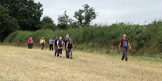
We took a footpath that crossed the River Pang on its way out of Stanford Dingley, heading west and then south, down to Chapel Row Common. From there we headed north, crossing the Pang once more before joining the road back into Bucklebury. It took me by surprise when we found ourselves back at the car park as the road looked quite different when coming the other way. See our route on Bing Maps.

📸 Back to Volume 17
Return to volume index